Chapter 2: Azonal Dry Loess Steppe
"With a thick tephra layer, insulating the former surface after the eruption, the frost table must have moved rapidly upward. The soil and vegetation beneath the ash froze, preserving features of the ancient surface and, were subsequently exposed, providing a unique ‘snapshot’ of the full-glacial landscape." Höfle, C. et al. (2000:145).
How much fodder would the wooly mammoth have found on this "full-glacial landscape", covered with wind-blown loess? It lies between the azonal dry loess steppe and the dry northern tundra and polar semi-desert, growing on very dry soil. This azonal dry loess steppe we find now in the southern part of the subartic Yukon Territory. The northern tundra is growing now in the northern part of the arctic tundra, close to the Arctic Sea. And the polar semi-desert we do find today north of the Arctic Coast, on the Arctic Islands. How much aboveground plant mass (dry weight) is growing there now per year? Could it support the mammoth, whole herds of mammoths? How much crude protein does this fodder contain during the long winter season, while the plants are dormant? What have they found out about the "Beringian Productivity Paradox"?
N.F. Laxton, C.R. Burn and C.A.S. Smith report in Arctic, Vol. 49, No. 2 (June 1996) p. 129-140 about "Productivity of Loessal Grasslands in the Kluane Lake Region, Yukon Territory, and the Beringian ‘Productivity Paradox’": "The Beringian ‘Production Paradox’ is posed by abundant evidence, that large ungulates populated unglaciated portions of northwestern North America and adjacent northeast Asia during the late Pleistocene, while botanical data from the same period suggest a poorly productive tundra environment. It is not clear, how the large animals sustained themselves, but portions of Beringia, locally in receipt of loess, may have harbored sufficient forage-producing plants, to nourish these animals. Loessal soils in the region today are warm and dry in summer, and are often used as rangelands. The loessal hypothesis was examined on grasslands in the Kluane Lake area, southwest Yukon Territory, at sites, which have recently received loess, blown from the Slims River delta. The biomass and species diversity of grasslands around the lake increase with the quantity of silt in the soil." Laxton, N.F. et al. (1996:129)
"Recently, Hoefle et al. (1994) discovered paleosols dating from 17,000 B.P. on the Seward Peninsula, Alaska. These soils were buried by tephra, incorporated in permafrost, and have remained frozen ever since. The paleosols developed in loess, with all horizons containing fine roots. On the basis of cryotexture, active layer depths of 40-70 cm have been interpreted for the paleosols, in comparison with 30-40 cm in modern soils nearby... Tufted graminoids and short woody plants characterize the specimens identified, suggesting the region could have supported small mammals at least. ... The environment in the study area, on the southern shores of Kluane Lake, has notable similarities with that postulated for Duvanny Yar (= Last Ice Age) ‘hot spots’." Laxton, N.F. et al. (1996:130, 131).
Kluane Lake Area
"The St. Elias Mountains form a prominent topographic barrier between the northeast Pacific Ocean and northwest North America. The Icefield Ranges form the core of these mountains, supporting the most extensive ice fields in continental North America. Kluane Lake lies in the Shakwak Trench, at the foot of the Kluane Ranges, the easternmost extent of the St. Elias Mountains."
Climate: "There is a marked contrast between the climates on the southwest and northeast of the St. Elias Mountains. The mountains not only provide a rain shadow on their lee slopes, but also effectively block the penetration of many maritime air masses into the Yukon, maintaining cool, anticyclonic conditions there in winter. The result is a semiarid, continental climate near Kluane Lake, with cold winters and warm, albeit short, summers.
"The aridity of the Kluane Lake region may be analogous to that of Duvanny Yar (= Last Ice Age) Beringia, which was caused not only by a rain shadow to the lee of the Cordilleran Ice Sheet, but also by the contraction of the Bering and Chukchi Seas. An important similarity between the environments is the low snowfall (55 mm snow water equivalent at Kluane Lake, Environment Canada, 1982), which gives easy access to forage plants in winter." – Laxton, N.F. et al. (1996:131, 132).
Active Loess Deposition: "The Slims River delta is 7 km², and comprises fine sand and silt. Vegetation is sparse, and is confined primarily to sediments near the valley walls. The lack of vegetation cover, low annual precipitation, and fine texture of the sediments make this material susceptible to eolian [wind] transport." (1996:132)
Vegetation
How much fodder is growing now on this dry loess-soil at Kluane Lake?
"The vegetation on mesic sites in the boreal zone is a white spruce forest, while various grassland associations occupy drier aspects. Johansen et al. (1989) concluded that an Artemisia-Festuca community, found in association with both open poplar stands and aspen forest, is the most productive rangeland in the region (see Table 2), but is confined to soils, which receive loess from outwash plains, such as the Slims River delta. Areas, not receiving loess, are dominated by plant communities with less forage production.
Table 2. Artemisia-Festuca communities in the Kluane Lake Region (after Johannsen et al., 1989).
Grassland Phase forage production 370 kg/ha (37 g/m²)
Aspen Phase forage production 480 kg/ha (48 g/m²)
The vegetation of the rangelands in the Kluane Lake region resembles that of Duvanny Yar hot spots to the extent that the Beringian environment comprised an open landscape ... There is no suggestion, that the white spruce forests of the Kluane Lake area had a counterpart in Beringia. ... The range of biomasses recorded was large and skewed, with values between 4.5 and 62 g/m²." – Laxton, N. F. (1996:133, 136)
Greater Kluane Planning Area
R. Johansen, M. White and M. Willoughby report about the Grazing Potential for selected Areas in the Greater Kluane Planning Region, 1989 Whitehorse. R. Johansen, and M. White Agriculture Branch, Dept. of Renewable Resources, Whitehorse, Yukon. M. Willoughby, Western Rangeland Consultants, Edmonton, Alberta, Canada.
Carex (sedge meadows)
Forage production: 620 kg/ha (62 g/m²)
Grazing capacity: 9 ha/AUY (0.09 km²/AUY).
1 animal unit AU (horse or cow) 455 kg. - Johansen, R. et al. (1989:3, 4).
AUY = 1 animal unit per year.
Artemisia-Festuca (grassland/parkland complex)
Vegetation: Grassland phase:
Forage production: 370 kg/ha (37 g/m²)
Grazing capacity: 15 ha/AUY (0.15 km²/AUY)
Aspen phase
Tree: Populus tremuloides:
Forage production: 450 kg/ha (45 g/m²)
Grazing capacity: 12 ha/AUY (0.12 km²/AUY)
This is the most productive dry grassland type. It provides good forage for domestic animals. It will green up early in the spring and have little snow cover during the winter. This type should not be overutilized, due to the potential for erosion on the steep south facing slopes. Soil overlain by windblown loess.
Kluane Lake: This area contains the largest area of productive rangeland in the region. The Artemisia-Festuca community is dominant all along the northeast shore of Kluane Lake. The community is established in areas, that receive loess, generated from outwash plains of the Slims and Donjek rivers. - Johansen, R. et al. (1989:5, 6, 14).
Glossary of Range Terms: Hectares per Animal Unit Month (AUM). The estimated number of hectares, necessary, to provide forage for one animal unit for one month under proper use. Animal Unit (AU): Considered to be one mature cow (455 kg) based upon daily forage consumption of 15 kg dry matter. A mature horse is equivalent to 1.25 AU. AUY = Animal Unit per Year. - Johansen, R. et al. (1989:36)
Comment: We should bear in mind here: This plant-cover near Kluane Lake lies in the southern part of the Yukon Territory, at the southern limit of sporadic permafrost. The climate is subarctic. One cannot compare it at all with the arctic tundra near the Arctic Coast, where it is so cold in summer and so short, that trees will not grow, where the permafrost is continuous.
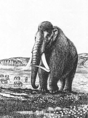
Woolly mammoth bull in central northern Siberia, with wild steppe horses in background. From: A. J. Sutcliffe, On the track of the Ice Age mammals (1985), British Museum (Natural History), London.