Chapter 1: Northernmost Muskox
How far north is the muskox living now? How much fodder is growing there? Could the woolly mammoth have grazed up there, just like the muskox of today? This northernmost muskox range will clearly show us, how the mammoth would have fared, if it had tried, to live during the height of the Last Glaciation on the wind-blown loess-steppe or steppe-tundra near the rim of the ice sheets.
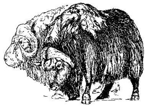
Muskoxen (Ovibos moschatus). From W. von Koenigswald. In: H. Miller-Beck, Urgeschichte in Baden-Württemberg (1983:201) Fig. 103.
Muskox on Canadian Arctic Island
How is the muskox able, to survive up there? When will it be able to survive? When will it perish?
D.C. Thomas, F. L. Miller, R. H. Russel, Canadian Wildlife Service, Edmonton, Alberta, and G. R. Parker, Canadian Wildlife Service, Sackville, New Brunswick, report in. Arctic Vol. 34, No. 1 (March 1981) pp. 34-36, under the heading, "The Bailey Point Region and Other Muskox Refugia in the Canadian Arctic: A Short Review":
"The muskox (Ovibos moschatus) is widely distributed over much of arctic Canada, but only at a few locations do their densities remain high and populations relatively stable. These refugia constitute the most favourable muskox ranges in the Canadian Arctic Archipelago – places, where muskoxen probably would probably survive under the most unfavourable climatic conditions. Extremes in winter weather cause other populations to ride a roller coaster of ups and downs, with local exterminations. Refugia for muskoxen in the High Arctic include lowlands on eastern Axel Heiberg Island in the Mokka Fiord region, the lowlands of northeastern Devon Island, and the Bailey Point region of Melville Island. All of those regions historically have supported high densities of muskoxen from time to time, but the Bailey Point region must be considered the best habitat for muskoxen in the Canadian High Arctic. (Bailey Point = on south side of Melville Island, near 71°N, and north of Banks Island)." Thomas, D.C. et al. (1981:34)
"The sedges and grasses of wet meadows are the preferred diet of muskoxen in summer; in winter that food source is supplemented with a greater intake of willows, grasses, and sedges from the exposed slopes and ridges (Parker, 1978).
"The best muskox habitat below 200 m in Canada seemingly can support 1-2 muskoxen/km² on a year-round basis, if winters are not too severe. Most ranges in the Canadian Arctic Archipelago are subject to occasional icing and deep compacted snow, which can markedly reduce populations. This factor complicates any estimates of long-term carrying capacities of muskox range." Thomas, D. C. et al. (1981:35)
What propitious circumstances of geography and climate produce a muskox haven at Bailey Point?
· First, the western High Arctic is in a zone of low total precipitation (8.5 cm/yr) with average annual snowfalls of only 58 cm at the nearest weather station at Mould Bay on Prince Patrick island.
· Second, the surrounding seas, particularly to the north, are mostly ice covered year-round and prevailing winter winds are out of the northwest quadrant; consequently rain or snow melt and subsequent ice formation is unlikely during winter.
· Third, the region generally is protected from prevailing northwest winds by interior highlands, and the lowlands are locally protected by the highlands of the peninsula, bordered on the windward side by impressive scarps.
· Fourth, the region contains productive lowlands, and fertile stream valleys, rounded by glacial action and overlain by till.
"Other centres of muskox populations in arctic Canada have similar favourable characteristics, that lessen or remove the potential for a winter disaster, caused by deep, hard, and prolonged snow cover or groundfast ice, ice layering in the snow or ice crusting of the snow. For example, an early winter rain storm, followed by heavy winter snows and a late summer, can create such difficult foraging conditions, that the majority of muskoxen in a population can starve in one winter. Worse still, two severe winters may occur consecutively or within a span of three years, leaving insufficient time for the animals, to recover their fat reserves. Fortunately these conditions may only occur in a given region once every 10-50 years. Many populations seem to be in a state of recovery following sudden declines." Thomas, D.C. et al. (1981:35, 36)
Snow density on Arctic Tundra
How dense is the snow on the arctic tundra in northern Alaska and further south in the taiga, in the forest-tundra and northern boreal forest? Will the muskox be able to graze there everywhere? We should remember here: The muskox on the arctic tundra on the Taimyr Peninsula, central northern Siberia, is able to graze in snow, which has a density of up to 0.25 g cm³. Also the bison, in the northern part of its range, in the southern part of Canada’s Northwest Territories, is grazing in winter in snow, which has a density of up to 0.25 g cm³.
The muskox is only able, to live in the Far North, if it is able to gain more energy from the food, which it is able to take in per day, than it must spend, while searching for and digging out this food beneath the snow. In order to survive the long arctic winter, when the best pastures in the lowland are buried beneath drifted snow, the muskox may be able to do two things:
1. It may look for a lush pasture in the lowland, close to sea level, where the wind cannot drift it over with dense snow. There might be a few places, where there are mountains or steep rock-cliffs, which shelter this fertile lowland during the winter from the storms. The snow-cover will not become then as dense, as out on the wind-swept open tundra or polar desert.
2. If there are no such fertile lowland meadows, close to steep mountains or rock cliffs, keeping the wind away in winter, the muskox must do then right the opposite. It will only be able to find then enough food during the long arctic winter in places, fully exposed to the winter storms: It must stay then at places, where it is the coldest in winter, where the wind has blown the snow away: That is, on top of wind-swept ridges, hills, and mountains. And on the steep cut-banks of the rivers. But at these places, there is only very little food.
How dense is the snow on the arctic tundra of Alaska? Will the muskox be able, to graze there everywhere during the long arctic winter? What have scientists found out now about this?
Carl S. Benson, Geophysical Institute, University of Alaska, Fairbanks, and Matthew Sturm, U.S. Army CRREL, Ft. Wainright, AK report about the "Structure and wind transport of seasonal snow on the Arctic slope of Alaska" in: Annals of Glaciology 18 (1993 :261-267). What have they found out? – That write:
"Tundra snow, found mainly on the Arctic slope north of the Brooks Range, is wind-packed, dry, and sastrugu-sculptured, with depth hoar at its base.
"Taiga snow, found in the taiga, between the Brooks and Alaska ranges, is characterized by low-density (< 0.2 cm³), loosely consolidated, depth hoar which makes up most of the snowpack in the lowland brush and forest areas. - The winter snow on the Arctic slope of Alaska lasts for nine months each year." (1993:261)
"Tundra snow: The basal depth hoar forms in the first layers of winter snow are subjected to extremely strong temperature gradients (>1° cm) immediately after deposition and for many months thereafter. ... The net relief of tundra tussocks ranges from 10 to 40 cm and, typically, the veneer snow is 20-40 cm deep as well. During autumn, the first few snowfalls may melt off from the tops of tussocks and leave pockets of new snow between the tussocks. Meltwater, draining from the tops, often saturates the snow between the tussocks to produce icy zones.
"After snow has filled the inter-tussock areas, subsequent snowfalls tend to drift over the tussock tops. Due in part to the uneven nature of the original snow surface, and in part to wind turbulence, the wind slabs that overlie the basal hoar tend to develop into sastrugi. ... As the winter progresses even dense wind slabs can begin to metamorphose into depth hoar. We have observed wind slabs as dense as 0.35 g cm³ metamorphose into depth hoar by the end of the season. In other cases, wind slabs of density 0.40-0.35 g cm³ have lasted intact from mid-December to the end of March. ...
"Depth hoar densities range from 0.15 to 0.25 g cm³, while medium-grained and wind-packed layers can range from 0.2 to 0.55 g cm³. The mean veneer density is at its minimum in less windy areas. A good example is the headwater region of Imnavait Creek (68°37´N, 149°17´W) near Toolik Lake, which is dominated by katabatic flow north from the Brooks Range. In 1985 an average density of 0.25 g cm³ was measured in the Imnavait watershed (Liston, 1986); in 1989 the average in this region was 0.28 g cm³. Higher densities occur in the areas farther out on the Arctic coastal plain and along the coast, where the stronger east-west winds predominate; there the average density generally exceeds 0.3 g cm³. An example is a mean density of 0.324 g cm³ measured in the Prudhoe Bay area (Benson and others, 1975)." Benson, C. S. et al. (1993:262, 263)
Fig. 1. Typical cross-section through the venter facies of tundra snow. The tundra tussock relief is a significant fraction of the total snow thickness and strongly affects the snow/ground Interface temperature.
Imnavait Creek, February 14, 1990. Height of snow layer up to about 40 cm. With hummocks rising up in there 10-40 cm from the ground-surface.
Snow density from top to bottom:
30-40 cm snow height, upper part, wind slab, extremely fine-grained, 0.40 g cm³, lower part, 0.30 g cm³.
10-25 cm height, depth hoar, chains of cups 0.23 to 0.27 g cm³
Imnavait Creek, February 14, 1990. Temperature at snow/ground interface. Air temperature –24°C. Where the snow lies on the ground, below a snow height of 20-40 cm. The temperature varies from about –15 to –23°C. - Benson, C. S. et al. (1993:262) Fig. 1.
Mean snow depth and density in northern Alaska
|
Depth range m |
Mean density g cm³ |
Maximum density g cm³ |
|
Taiga snow (mostly depth hoar) 0.4-0.9 m |
0.23 |
0.3 |
|
Tundra snow |
|
|
|
Veneer facies (depth hoar and wind-packed) 0-0.06 m |
0.25-0.30 |
0.55 |
|
New snow |
0.1 |
|
|
Medium grained |
0.2 |
|
|
Wind slab |
0.4-0.5 |
|
|
Depth hoar |
0.15-0.25 |
|
|
Drift facies (all wind-packed) 1-10 m |
0.38 |
|
Mean snow depth and density of tundra and taiga snow. Benson, C. S. et al. (1993:263) Table 1.
Typical cross-section through a drift in the tundra snow cover near Lake Noluck in the north-central Brooks Range. Cross-section through this drift-trap. - Benson, C. S. et al. (1993:263) Fig. 2.
Upper half of this drifted snow, 0-1 m from surface: 25-45 g cm³
Lower half of this drifted snow, 1-2 m from surface: 40-45 g cm³,
at bottom, on ground surface less, about 25 g cm³.
Fig. 5. Stratigraphic detail of the 1966 drift at the river bluffs at Atqasuk on the Meade River. Atqasuk (70°29´N, 157°25´W) on the Meade River about 95 km south-southwest of Barrow. The river banks are 10-20 m high and the meander loops provide exposure to wind drifting from all possible directions. (1993:264) Figure 5.
Temperature in this snow drift: -2°C near surface of this snow drift. The temperature in this snow drift goes down from –2° C near the surface to –11°C on top of the frozen ground.
Snow density in this snow drift: 0.217 g cm³ near surface, going down to 0.420 g cm³ in middle of this snow drift, at a depth of about 1 m. - Benson, C. S. et al. (1993:264)
North Greenland
David Klein, U. S. Fish and Wildlife Service, University of Alaska, at Fairbanks, and Christian Bay, Botanical Museum, University of Copenhagen, Denmark, have studied the "Foraging dynamics of muskoxen in Peary Land, northern Greenland." They write:
"Muskoxen Ovibos moschatus in northern Greenland (79-83°N) are at the northern limit of their distribution and exist under seasonal extremes, dominated by nearly 10 months of winter, much of which is without sunlight. The period of summer vegetative growth is less than two months. In the Kap København area (82°30´N), diversity of plant species is low (76 species of vascular plants) and forage biomass in major vegetation types in summer varies from over 40 g/m² in sedge-dominated fens (= bogs) to <5 g/m² in polar barrens. Nonetheless, 90-95% of the ice-free area consists of barren ground or sparsely vegetated polar desert." (1990:269).
"The natural distribution of muskoxen Ovibos moschatus is from 65°N latitude in the vicinity of the Thelon River in Northwest Territories, Canada to nearly 84°N in Peary Land, North Greenland, the world’s northernmost area. Vegetation of North Greenland is sparse and scattered and species diversity is low. Polar desert and barrens are widespread and constitute >90% of the ice-free area. The more richly vegetated sites are restricted to low-lying areas 0-300 m above sea level. Upland areas have only a scattered fell-field vegetation, with plant cover of <1%..." Klein, D. R. and C. Bay (1990:269, 273).
We shall look now briefly at two of the sites in northern Greenland, which they have studied: Kap København and Blasø. How much fodder is growing up there?
Kap København (82°30´N, 21°30´W), North Greenland
Station Nord, southeast of Kap København, 227,3 mm ppt yr. It lies 10 km from the coast and "is richly vegetated". From 15 July – 9 August1987, this very fertile area contained this much aboveground vegetation:
Willow (Salix arctica) slopes: 21.1 g DM/m² year, 2.3% of ground covered.
Sedge (Carex stans) fen (bog):
Carex stans 23.0 g DM/m² yr 4.9-9.6% cover
Willow 16.5 g DM/m² yr <1-11.4% cover
Total 39.8 g DM/m² yr
Polar barren
Dominated by willows. Total 5.1 g DM/m² yr >1% cover
Blasø (79°37´N, 23°15´W), North Greenland
Close to inland ice, ca. 70 km from coast. This is true polar desert, with low precipitation (probably <100 mm) away from the coast.
Sedge (Carex stans) fen (bog) 3.5% cover 25.1 g DM/m² yr
Polar barren (willow) <1% cover 12.0 g DM/m² yr
From: Klein, D. R. and C. Bay (1990:271).
Result
What does this show us? - This clearly shows me, how much fodder the woolly mammoth would have found, if it had tried to graze during the height of the Last Glaciation on wind-blown loess-steppe (or steppe-tundra) near the rim of the ice-sheets.
In the most fertile spots, on the sedge meadows, 23.0 g DM/m² would have grown. But it would have covered only 7.25% of the ground, not covered with ice. – Dwarf willows were covering then 5.5% of the ice-free ground. They are producing only 16.5 g DM/m² year. But there had to be then 227 mm of precipitation per year. During the height of the Last Glaciation, there would have been only less than half that much precipitation.
Many of the world’s leading ice-age experts do conclude, that during the height of the Last Glaciation, annual precipitation must have been very low: only about 90-100 mm per year. I do agree with this. But at this low annual precipitation, only polar desert could have grown near the rim of the continental ice sheets. Blasø, at 79°N in North Greenland, shows us, what this periglacial polar desert must have been like, with its annual precipitation of less than 100 mm. Blasø lies close to the northern rim of Greenland’s ice sheet and about 70 km away from the coast.
3.5% of the ice-free ground is covered with sedge-fen (= bog). But these sedges are producing only 25.1 gDM/m² per year. – Less than 1% of the ice-free ground is covered with dwarf willows. These tiny willows are producing 12.0 gDM/m² year. Thus, 95.5% of the ice-free ground is barren. It is covered with frost-split rocks, gravel and sand.
Canadian High Arctic Islands: Plant Production
|
Location |
Stand no. |
Aboveground live (g m²) |
Production above (g m² y) |
Community type |
|
Melville Is. 75°N |
No. 3 No. 6 Mean |
Brown 48.3 Green 24.8 Brown 1.3 Green 11.9 Brown 24.8 Green 18.3 |
24.8 11.9 18.3 |
Cushion plant-low shrub Cushion plant-herb |
| Banks Island. 73°N Big River |
No. 1
|
Brown 216.8 Green 22.4 |
15.2
|
Dryas-C. rupestris |
|
Thompson River Banks Island |
No. 9 |
Brown 212.6 Green 87.0 |
54.8 |
Cushion plant moss |
|
Johnson Pt Banks Island |
No. 22 Mean |
Brown 275.3 Green 33.4 Brown 199.0 Green 37.7 |
21.4 |
Dryas-Salix spot stripped semi-desert |
|
Victoria Is. 71°N |
No. 32 No. 37 Mean |
Brown 82.3 Green 25.7 Brown 165.8 Green 58.1 Brown 124.0 Green 41.9 |
21.2 41.4 31.3 |
Cushion plant-herb fellfield Dryas-C.rupestris |
Standing crop and production estimates of some Polar Semi-desert sites of Melville, Banks, and Victoria Islands, N.W.T. Adapted from J. Svoboda (1977:206) Table 12.
In such a polar desert, the poor mammoth would have had to live during the height of the Last Glaciation, near the rim of the continental ice sheets, if the ice-age experts were telling the truth. The elephant would have pitifully starved, thirsted and frozen there to death within a few weeks, if not days. The elephant is still able to live, where 250 g DM/m² yr have grown during 8-9 wet months, followed by 3-4 dry months. During the great drought of 1970-71 in Tsavo East N. Park, East Africa, about 5000 elephants and several hundred black rhinos have starved to death with a full stomach, where only 200 gDM/m² had grown per year from 235 mm of rain. (Phillipson, J. 1975:176). The asserted adaptation of the woolly mammoth to severe arctic cold is not science, only science-fiction. It has nothing to do with serious scientific research.