Chapter 3: Ice-free corridor and mammoth-steppe
The mammoth is supposed to have come from north-eastern Siberia into North America, when sea-level was 100-200 meters lower than now, because this water was stored then in the continental ice sheets. That was at the height of the Last Ice Age, when most of North America was covered by ice-domes, several kilometres thick. At least at some times during the Ice Age, there was an ice-free corridor, east of the Rocky Mountains, they say: between the ice sheet, which covered the Rocky Mountains and the ice sheet further east, which covered the central and eastern part of North America.
The herds of mammoths, bison, and wild horses grazed in eastern Beringia (Alaska and the Yukon), where there was no ice, in so-called refugia, between the ice sheets. This ice-free area was covered then by a Mammoth Steppe or tundra-steppe. It was so productive, they say, that large herds of mammoths, bison and horses were able to live there during the whole year, also during the long arctic winter. These herds of hoofed animals have also lived up there during the height of the Last Ice Age. Some of those mammoth herds then went further south into southern Canada and the continental United States, south of the ice sheet. They wandered south through the ice-free corridor.
What kind of a plant-cover was growing then in this “ice-free corridor”, in what kind of a climate? How much fodder was growing then in this ice-free corridor east of the Rocky Mountains? What scientific proof is there for this belief? What have scientists found out now about this?
North America during the Ice Age, with the largest size of the continental ice sheets - - - - -, and when it had melted back (hatched area). According to: Lisa W. Nelson, in Mammoth Graveyard, The Mammoth Site of Hot Springs, South Dakota (1994:19).
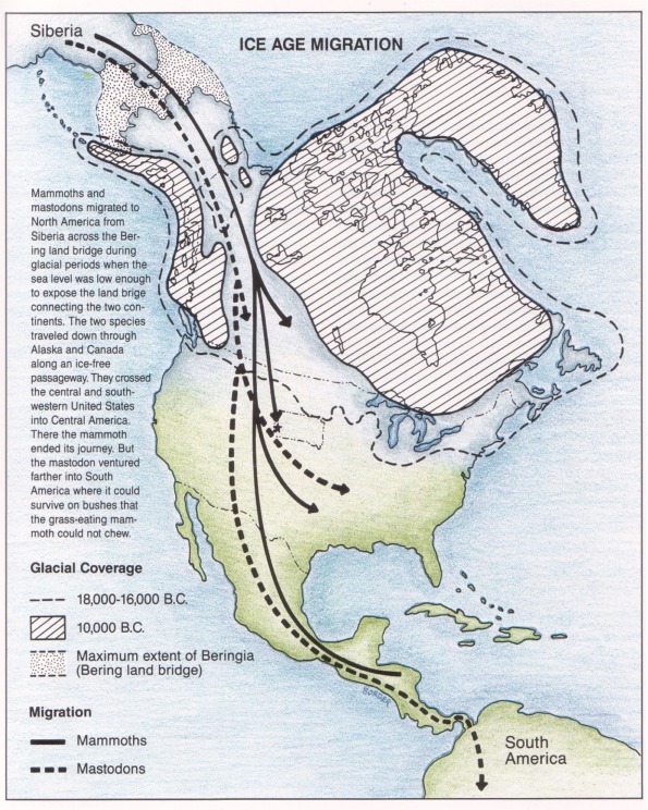
The text at the left says: Mammoths and mastodons migrated to North America from Siberia across the Bering land bridge during glacial periods when the sea level was low enough to expose the land bridge connecting the two continents. The two species travelled down through Alaska and Canada along an ice-free passageway. They crossed the central and south-western United States into Central America. There the mammoth ended its journey. But the mastodon ventured farther into South America where it could survive on bushes that the grass-eating mammoth could not chew.
The star at the tip of the one black line, in the middle of the northern United States shows us, where The Mammoth Site of the Hot Springs, in South Dakota, is located.
Glacial Coverage: - - - 18,000-16,000 years ago. Dotted area: Maximum extent of Beringia (Bering land bridge)
Migration: ________ Mammoths. - - - - - - - Mastodons.
Carole A. Mandryk
I would like to quote here from an interesting research report from a book, which comes from the same source: Megafauna & Man: Discovery of America’s Heartland. Editors: Larry D. Agenbroad, Jim I. Mead, Lisa W. Nelson. The Mammoth Site of Hot Springs, South Dakota, Inc. Scientific Papers, Volume 1, August 1990, pages 67-79.
“Could Humans Survive the Ice-Free Corridor?: Late-Glacial Vegetation and Climate in West Central Alberta” by Carole A. Mandryk, Department of Anthropology, University of Alberta, Edmonton, Alberta.
“Abstract: A radiocarbon-dated sediment core from a small lake within the postulated corridor provides a pollen record of late- and postglacial vegetation. Located 18 km southwest of Rocky Mountains House, Alberta, Canada, in the aspen parkland/western boreal forest transition zone, Mitchell Lake yielded a 552 cm sediment core. Three 14C accelerator dates and two tephras provide a chronology back to at least 17,960 yr B.P. and date four local pollen zones.
The paleoecological data demonstrate that a cold semiarid Artemisia steppe, characterized by 10 to 25% ground cover and 5 to 25 cm yr precipitation existed in the corridor area from approximately 18,000 to 16,000 B.P. The birch zone continued until approximately 11,400 yr B.P., when Picea [spruce] migrated into the region.
It is unlikely that the initial vegetation, with its extremely low primary productivity and biomass, could have supported a fauna capable of sustaining viable human populations. During the birch zone, however, particularly by 14,000 yr B.P., during deglaciation and widening of the corridor, primary [plant] productivity would have increased greatly and could have supported increasing viable flora and fauna.”
Study Area
“Mitchell Lake, 52° 13’N, 115°N, 115°30’W, is located at 1050 m elevation, approximately 18 km south-west of the town of Rocky Mountain House, Alberta [southwest of Edmonton]. The area is within the eastern lowlands region of the Rocky Mountain foothills of west central Alberta, an area of transition to the eastern plains.”
Discussion of dates
“Dating lake sediments in the ice-free corridor area is often problematic, as the region is underlain by carbonaceous bedrock and surficial deposits, which are the source of ‘old’ carbon that dilutes the local 14C:12C ratio (Lowe and Walker 1984:237; MacDonald et al. 1987:837). Coal-rich sediments and organic material from older deposits also enrich lakes with high proportions of inert carbon (Nambudiri et al. 1980:123; Hickman et al. 1984:1438). These additions of 14C deficient carbon are often present in lake sediments in the corridor region and can result in apparent ages of samples that date thousands of years older than their true age.
The immediate postglacial environment is particularly vulnerable to error caused by the influence of old carbon. The combination of dissolved carbonates and other inorganics washing in from bare mineral soils and a sparse vegetation cover results in sediments that are high in inorganics and or in organic carbon. It is now recognized that dates of sediments containing less than 2% organic carbon are likely to be in error (Bjorck and Hakansson 1982; King 1985:168).” Carola A. Mandry Megafauna and Man (1990:67-70)
Vegetational and Environmental History, Zone ML-1 (>18,000 to 16,100 yr B.P.)
“I propose that the Mitchell Lake herb zone is best characterized as a cold, semiarid steppe that is dominated by Artemisia. The vegetation in the Mitchell Lake vicinity could be either a pioneering vegetation or a vegetation characteristic of an unstable periglacial environment, which could be the situation if the region remained unglaciated throughout the Late Wisconsin.
The stratigraphy of the lowermost 150 cm of the Mitchell Lake core shows high percentages of sand, silt, and clay. This could be interpreted as a relatively rapid deposition of lake sediments that were washed out of glacial deposits during the initial stages of the Late Wisconsin Laurentide ice recession, and the drainage of glacial Lake Caroline when a vegetation-free landscape could have been modified at a comparatively high rate.
Secondly, it must be stressed that by labelling the vegetation a cold, semiarid Artemisia steppe, I by no means envision a uniform homogeneous environment. Although Artemisia is clearly dominant, with values up to 78%, it is not the only taxa in the record. Salix [willow] and Cyperaceae [sedges] would have been present in moister lowland areas. Sarcobatus may have been common, especially on the seasonally dry edges of such moist areas. And low occurrences of Populus [poplar] do indicate its presence, likely on river floodplains and other protected areas.
The distinguishing aspect of the environment would have been extensive areas characterized by very sparse, discontinuous xeric [dry] vegetation composed primarily of Artemisia, along with grasses and various open-ground herbs. My characterization of the Mitchell Lake assemblage as Artemisia steppe rather than grassland is supported by both very high percentages of Artemisia (38 to 78%), and high Artemisia/Gramineae [grasses] ratios. These associations have very low ground cover, always less than 100% (unlike grassland), and often as little as 10 to 50%.
Such sparse vegetation is an adaptation to severe moisture stress, which is why high Artemisia/Graminea ratios, i.e., Artemisia-dominated vegetation, are accurate indicators of aridity. Soil moisture rather than temperature is the critical environmental factor that determines the composition and distribution of plants in the steppes and grasslands. While grasses are often vulnerable to a lack of summer rains, Artemisia has long been noted to increase markedly under drought conditions.” Carola A. Mandryk Megafauna and Man (1990:74, 75).
“Permafrost indicators suggest a temperature of at least 5 to 10° C and perhaps colder closer to the ice sheets. Despite the cold, stronger radiation in the lower latitudes may have caused higher evaporation stress than would be expected in an equivalent ‘arctic’ climate. The short, warm summers with little precipitation could allow soils to thaw deeply enough to provide a well-drained, dry upper surface. The strong winds from all directions would also contribute to both dry soils and an open landscape. Perhaps ‘Artemisia semi desert’ would indicate the extreme dryness and lack of vegetation better than ‘Artemisia steppe’. This would, of course, be a cold desert, the use of the term desert implies unwarranted warmth to many people.”
Discussion and Conclusions
“The cold, semiarid Artemisia steppe vegetation reconstructed for Zone ML-1 [18.000-16.100 yr B.P.] would likely have had 10 to 25% ground cover and precipitation of ca. 5 to 25 cm a year. A similar to desert scrub and semi desert environments in terms of aridity, percentage ground cover, and representative taxa, such vegetation may have had similar rates of primary productivity and standing biomass. Primary [plant] productivity for semi desert scrub is estimated by Barbour et al. (1980) at 10 to 250 g/m², with an average of 90 g/m² year, and standing biomass [mostly old dry aboveground vegetation] of .1 to 4 kg/m² with an average of .7 kg/m². This is very close to, although even less than, the estimates of primary production and biomass for tundra and alpine environments of 10 to 400 (average 140)g/m² year and .1 to 3 (average .6) [mostly old, dry aboveground vegetation], respectively. Thus, instead of the steppe being a highly productive ecosystem, it was less than or equal to high- and mid-arctic tundras of today. The majority of Zone ML-1 intervals would have been similar to the very low productivity of fell-field and rock desert tundras, where mammals and birds are rare due to the extremely low biomass.
It is considered unlikely that such sparse vegetation in harsh climatic conditions could have support fauna capable of sustaining viable human populations. By the end of ML-2 times [14,000 years ago], however, the primary [plant] productivity and biomass would have increased greatly.” Carola A. Mandryk Megafauna and Man (1990:76, 77)
Result
At the peak of the Last Ice Age and shortly thereafter in Western Canada (Alberta), there was supposed to be an ice-free corridor. It lay east of the foothills of the Rocky Mountains. It connected the ice-free areas of the Bering land bridge, Alaska, and the Yukon Territory with the ice-free area south of the continental ice sheet. Through this ice-free corridor the mastodon, the southern mammoth and the woolly mammoth are supposed to have moved southward into the southern parts of the continental United States and into Central America. That has always been during the coldest parts of the different ice ages, because then the Bering Strait was bare ground, and Northeast Siberia and West Alaska were connected, because the sea level was then about 100-200 m lower than now, and because this water was locked up then in the continental ice sheets.
Research in this assumed “ice-free corridor” in Alberta has shown us now:
This disproves the assertion: The ice-free area in Alaska, the Yukon Territory and on the ice-free corridor between the two ice sheets could have supported whole herds of mammoths, bison, and horses.
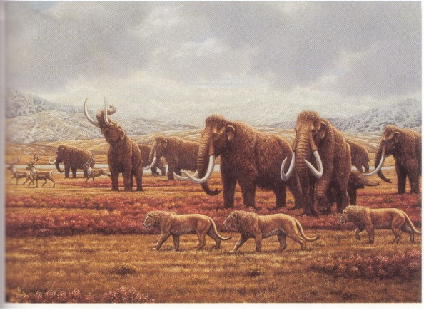
Lions and mammoths and reindeer in the upper Pleistocene. The mammoth cows are upset, because the lions could attack and kill their calves. That is why they closely watch the pride of lions. From: Mauricio Antón and Alan Turner The Big Cats 1997 Plate 7. Columbia University Press.